Edinburgh offers several gentle hiking trails that cater to novice walkers seeking scenic views without technical climbing. Key beginner routes include Arthur’s Seat, Blackford Hill, Calton Hill, Harlaw Reservoir, and the Water of Leith Walkway.
- How Do You Hike Arthur’s Seat Safely as a Beginner?
- What Makes the Pentland Hills Reservoir Walks Ideal for Beginners?
- How Can Beginners Explore the Hermitage of Braid and Blackford Hill?
- Why Is the Water of Leith Walkway Perfect for First-Time Walkers?
- What should beginners wear for easy hikes around Edinburgh?
- Are these beginner hiking trails accessible by public transport?
- How long do easy beginner hikes near Edinburgh usually take?
- Are beginner trails near Edinburgh suitable for walking dogs?
- What is the best season to attempt these beginner walks?
These paths feature paved surfaces, gradual inclines, clear direction markers, and direct access via public transport from the city centre.
The landscape of Lothian provides accessible outdoor recreation for individuals of all fitness levels. Beginners in Scotland often seek paths that minimize elevation gain while delivering views of historical landmarks and natural terrain.
The geographical position of Edinburgh places extinct volcanoes, protected woodlands, and coastal paths within a short radius of urban transit hubs.
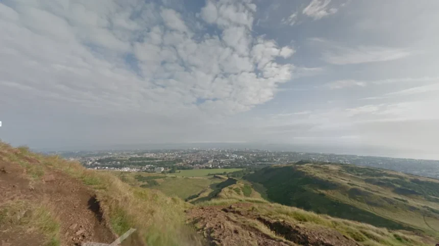
Arthur’s Seat stands as the most prominent natural landmark in Holyrood Park. Rising to 251 meters above sea level, this extinct volcano provides a full panorama of the city and the Firth of Forth.
Novice hikers usually choose the radical road route or the grassy eastern slopes starting at Dunsapie Loch. These paths avoid the rocky scramble of the western face and maintain a steady, manageable incline.
Blackford Hill and the Hermitage of Braid nature reserve present an integrated trail system south of the city core. Walkers move through a sheltered woodland gorge along the Braid Burn before climbing the gentle slopes of Blackford Hill itself.
The summit reaches 164 meters, offering clear lines of sight toward Edinburgh Castle and the Pentland Hills range. The terrain consists primarily of soil paths, wooden boardwalks, and stone steps.
Calton Hill is the most accessible elevated trail within the urban area. Located at the eastern end of Princes Street, this UNESCO World Heritage site features paved stone walkways and wide staircases.
The total walking distance around the perimeter loop measures approximately 1.3 kilometers, with an elevation gain of less than 50 meters. It serves as an entry-level walk for individuals looking to build physical stamina.
Harlaw Reservoir sits at the foothills of the Pentland Hills Regional Park near Balerno. The circular walk around Harlaw and the adjacent Threipmuir Reservoir covers roughly 5 kilometers of flat, crushed-gravel path.
It features minimal elevation changes and provides views of open water, coniferous woodland, and surrounding hill summits.
The Water of Leith Walkway is a continuous 19.6-kilometer linear river path extending from Balerno to the port of Leith. Beginners can easily complete short segments, such as the 3-kilometer stretch between Dean Village and the Royal Botanic Garden. The trail follows the flow of the river along flat asphalt and dirt paths, completely separated from vehicular traffic.
How Do You Hike Arthur’s Seat Safely as a Beginner?
Hiking Arthur’s Seat safely requires selecting the gentle eastern path from Dunsapie Loch, wearing supportive footwear with tread, monitoring weather conditions, and staying on designated routes. Hikers should carry water, dress in layered clothing, and avoid steep, rocky scrambles along the western crags.
Holyrood Park covers 260 hectares of volcanic landscape established as a royal park in 1541. The central peak, Arthur’s Seat, formed from an extinct volcano system that erupted roughly 350 million years ago during the Carboniferous period.
Glacial erosion during the last ice age exposed the hard basalt and dolerite rock, creating steep cliffs on the west and gentle slopes on the east.
Beginners must select their route carefully before starting the ascent. The safest and easiest path begins near Dunsapie Loch on the eastern side of the park. This route follows a wide, grassy path that climbs gradually toward the rocky summit.
The total distance from the loch to the summit is roughly 1.5 kilometers, making it significantly easier than the steep staircases near Holyrood Palace.
Footwear plays a critical role in safety on Arthur’s Seat. The volcanic rock near the summit becomes polished and slick from millions of footsteps over centuries. Rain and frost make these basalt surfaces treacherous.
Walkers need sturdy training shoes or light hiking boots with deep rubber lug soles to maintain traction on wet stone and mud.
Scottish weather changes rapidly due to maritime air masses moving across the North Sea. Wind speeds at the summit of Arthur’s Seat often measure two to three times higher than at street level in the city centre.
Hikers should dress using a three-layer system consisting of a moisture-wicking base layer, an insulating mid-layer, and a windproof, waterproof outer jacket.
Navigation in Holyrood Park is straightforward, but straying from marked paths creates unnecessary hazards. The western side of the hill features Salisbury Crags, sheer vertical cliffs dropping over 40 meters.
Historic rockfalls led to the partial closure of certain lower paths, such as the South Radical Road. Hikers must obey all safety signage and remain on established trails to prevent falls.
Public transit provides convenient access to the start of the trail. Lothian Bus routes 35 and 6 stop near the Scottish Parliament and the palace entrance, while route 68 stops near Commonwealth Pool on the southern side. Walkers can easily access the trail networks without private vehicles.
What Makes the Pentland Hills Reservoir Walks Ideal for Beginners?
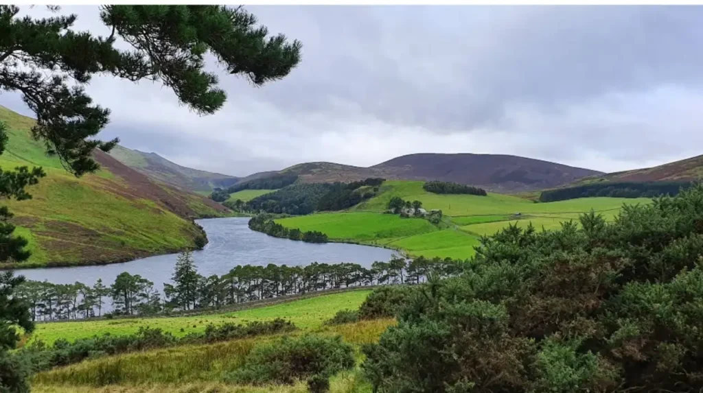
Pentland Hills reservoir walks offer flat, gravel-surfaced circular paths around body of waters like Harlaw and Threipmuir. These routes feature minimal elevation changes, clear signposting, parking amenities, visitor services, and protection from strong hill winds, making them ideal for novice walkers.
The Pentland Hills Regional Park spans a 32-kilometer range of hills stretching southwest from Edinburgh into Midlothian and Scottish Borders.
While the highest peaks, such as Scald Law at 579 meters, require substantial stamina, the lower valley basins feature gentle reservoir circuits. These paths allow beginners to experience rural Scottish landscapes without navigating steep hill climbs.
Harlaw Reservoir represents the primary entry point for beginner walkers in the Pentlands. Constructed in the mid-19th century as a compensation reservoir for industrial mills along the Water of Leith, the site now serves as a protected nature reserve.
The circuit around Harlaw Reservoir measures approximately 3 kilometers along a flat, wide path surfaced with packed gravel and timber edges.
Threipmuir Reservoir connects directly to Harlaw via a short, forested neck of land. Adding the Threipmuir loop expands the walk to roughly 5 kilometers while maintaining a flat gradient throughout.
The route crosses a red wooden footbridge over the connecting channel and follows the timbered shore through pine trees and open wetland habitats.
Facilities at the Harlaw Visitor Centre enhance the experience for first-time hikers. The centre provides accessible public restrooms, maps, route guides, and automated park ranger updates.
Parking spaces, including designated accessible bays, sit immediately adjacent to the main trailheads.
Wildlife watching is a major highlight along these low-elevation water routes. Hikers frequently observe grey herons, mallards, tufted ducks, and common toads around the reed beds. The surrounding woodland shelters red squirrels, roe deer, and various songbird species.
Transportation to the Pentland reservoirs is available via public buses combined with a short approach walk.
Lothian Bus route 44 runs regularly from central Edinburgh to the village of Balerno. From the final bus stop on Balerno High Street, a paved pedestrian path leads south for 1.5 kilometers directly to the Harlaw Visitor Centre gates.
How Can Beginners Explore the Hermitage of Braid and Blackford Hill?
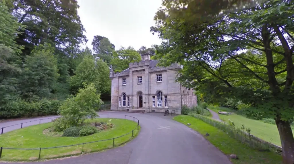
Beginners can explore the Hermitage of Braid and Blackford Hill by following the linear Braid Burn woodland path before ascending the broad, grassy northern trail to the summit. This combination provides a low-impact woodland walk paired with a short hill climb featuring scenic city vistas.
The Hermitage of Braid is a local nature reserve situated in a deep, wooded ravine carved by the Braid Burn over thousands of years. The valley shelters ancient deciduous trees, including beech, oak, and sycamore. The sheltered position of the ravine protects walkers from cold winds, creating a calm environment during autumn and winter months.
The walk typically begins on Braid Road or Hermitage Drive in Morningside. Hikers follow a smooth, asphalt and dirt path that runs parallel to the flowing stream for roughly 1.5 kilometers.
The route passes historical architecture, including the 18th-century Hermitage House, a Category A-listed Gothic mansion that now serves as a visitor centre and park ranger office.
Further along the ravine path, walkers encounter a historic stone icehouse and a restored doocot built to house pigeons in past centuries.
The flat terrain along the stream makes this lower section suitable for walkers of all ages and physical capabilities, including families with young children and dog walkers.
Transitioning from the woodland ravine to Blackford Hill involves a short, steady climb up stone steps and earthen footpaths. The hill rises to an elevation of 164 meters above sea level. The northern slope offers the most gradual ascent, featuring broad, grassy tracks that avoid steep drops or scrambles.
At the summit of Blackford Hill sits the Royal Observatory Edinburgh, established at this location in 1896. The top of the hill provides an unobstructed 360-degree view of the Edinburgh skyline, including Castle Rock, the Firth of Forth, and the distant Bridges at Queensferry.
Public transit access to Blackford Hill is highly efficient. Lothian Bus routes 11, 15, and 16 serve Morningside Road, located a 5-minute walk from the western entrance. On the eastern side, Lothian Bus route 41 stops near Blackford Pond, where another easy entrance leads directly into the nature reserve.
Why Is the Water of Leith Walkway Perfect for First-Time Walkers?
The Water of Leith Walkway is perfect for first-time walkers because it features a completely flat, non-technical terrain that follows a river through urban parks and historic villages. Walkers can easily customize their route length using frequent public transport exit points.
The Water of Leith is the main river flowing through Edinburgh, originating in the Pentland Hills and emptying into the Firth of Forth at Leith. The river historically powered dozens of flour, paper, and textile mills along its banks during the Industrial Revolution. Today, the river path functions as a green corridor for wildlife and pedestrians across the city.
The entire walkway covers 19.6 kilometers, but its linear design allows first-time walkers to choose short, manageable sections. The path is continuous, well-marked with brown directional signs, and almost entirely free of motor vehicle traffic. Surface materials range from smooth asphalt to well-compacted crushed stone.
One popular beginner section stretches between Slateford and Dean Village, covering approximately 4 kilometers. This segment passes through the Union Canal aqueduct area and quiet woodland parks. Walkers encounter minimal elevation changes while moving through historic industrial spots, including old mill race structures and stone bridges.
Another exceptionally scenic segment connects Dean Village to the neighborhood of Stockbridge, spanning roughly 1.5 kilometers. Dean Village features 19th-century workers’ housing built by the Water of Leith Village Incorporation. The path winds beneath the soaring arches of the Dean Bridge, designed by civil engineer Thomas Telford in 1831.
Accessibility is a key structural advantage of the Water of Leith Walkway. Every section of the path intersects major city streets, providing immediate access to Lothian Bus services. Walkers can end their hike at almost any point, step onto a main road, and take a bus back to their starting location or hotel.
What should beginners wear for easy hikes around Edinburgh?
Beginners should wear sturdy athletic shoes or light hiking boots with good rubber traction to prevent slipping on wet grass and rocks. Clothing should be layered, including a breathable base layer, an insulating fleece mid-layer, and a reliable waterproof and windproof outer jacket.
Are these beginner hiking trails accessible by public transport?
Yes, all major beginner trails around Edinburgh have direct access via public transport services operated by Lothian Buses or ScotRail. Most trailheads sit within a short walking distance of regular bus stops connecting directly to the city centre.
How long do easy beginner hikes near Edinburgh usually take?
Most beginner hikes near Edinburgh take between 1 and 2.5 hours to complete, depending on the chosen distance and pace. Short loops like Calton Hill take under an hour, while circular walks around reservoirs or hill summits average 4 to 5 kilometers.
Are beginner trails near Edinburgh suitable for walking dogs?
Yes, trails like Blackford Hill, the Water of Leith Walkway, and Harlaw Reservoir are extremely popular with dog walkers. Owners should keep dogs under close control or on a leash, especially in areas with nesting birds, livestock, or steep drops near Salisbury Crags.
What is the best season to attempt these beginner walks?
These beginner walks are manageable year-round due to well-maintained paths, but late spring through early autumn provides warmer temperatures and longer daylight hours. Winter walking requires extra care regarding icy paths and early afternoon sunsets.