Arthur’s Seat is an extinct volcano standing 251 metres above sea level, located in Holyrood Park at the eastern end of Edinburgh city centre in Scotland. It forms the main peak of a volcanic group dominating the capital’s skyline.
- How did Arthur’s Seat form geologically?
- What myths and legends are associated with Arthur’s Seat?
- What are the primary walking routes to the summit of Arthur’s Seat?
- What safety precautions and tips should visitors know before climbing?
- What wildlife and habitats exist in Holyrood Park?
- What archaeological and historical sites are found on Arthur’s Seat?
Arthur’s Seat sits within Holyrood Park, a royal park covering 260 hectares directly adjacent to the Palace of Holyroodhouse. The structure represents an ancient extinct volcano that originally formed millions of years ago. The geological feature forms the highest point of Edinburgh, providing panoramic views across the Firth of Forth, Lothian, and the Scottish borders. It lies approximately 1.6 kilometres east of Edinburgh Castle and marks the natural terminus of the Royal Mile.
The site functions as an open public space managed by Historic Environment Scotland. The geographic layout of the park comprises multiple distinct landforms including Salisbury Crags, Samson’s Ribs, St Margaret’s Loch, and Duddingston Loch. The entire area is classified as a Site of Special Scientific Interest due to its rare flora, fauna, and geological structures.
How did Arthur’s Seat form geologically?
Arthur’s Seat formed 350 million years ago during the Carboniferous period through sub-tropical volcanic eruptions that deposited basaltic lava, volcanic ash, and igneous rocks over millions of years of active geological accumulation.
The origin of Arthur’s Seat traces back to an active volcanic vent operating during the Carboniferous geological period. Magma erupted through the surrounding sedimentary rocks, creating layers of basalt, tuff, and agglomerate. When the volcano became extinct, the main vent solidified, creating a dense plug of volcanic rock that resisted later surface erosion.
Subsequent geological processes transformed the volcanic cone into its modern topography. Glacial erosion during the last Ice Age approximately 20,000 years ago moved west to east across the region. The moving glaciers carved away the softer surrounding sedimentary rock while leaving the hard igneous volcanic pipe intact, a classic geological process known as crag and tail formation.
3 types of volcanic rock features remain visible on the landform, including basalt columns at Samson’s Ribs, dolerite sills at Salisbury Crags, and volcanic agglomerate at the central summit. Modern geological science originated at this location through the field studies of James Hutton during the 18th century. Hutton identified the intrusion of molten rock into sedimentary strata at Hutton’s Section on Salisbury Crags, establishing fundamental concepts of uniformitarianism and deep time.
What myths and legends are associated with Arthur’s Seat?
Arthur’s Seat is famously linked to King Arthur as a possible location for Camelot, along with local folklore involving Celtic dragon legends, May Day morning dew rituals, and mysterious 1836 miniature coffins.
The most prominent myth identifies the hill as the location of Camelot, the legendary court of King Arthur. Historical records first document the name “Arthuris sete” in 1508 within Scottish literary works, reflecting medieval interest in Arthurian heritage among the Stewart monarchy. Alternative linguistic theories suggest the name derives from Gaelic terms including Àrd-na-saighead, meaning the height of arrows, or Àrd-thir Suidhe, meaning place on high ground.
Celtic folklore includes a prominent myth alleging that Arthur’s Seat is a sleeping dragon. According to local legend, the dragon consumed local livestock until it fell asleep and turned to stone, forming the silhouette visible against the skyline. Another long-standing tradition involves young women climbing to the summit on May Day morning to wash their faces in dawn dew to secure perpetual beauty and good fortune.
Historical mysteries also surround the physical site. In 1836, young boys hunting rabbits discovered 17 miniature wooden coffins hidden in a small cave on the northern slopes. Each coffin contained a carved wooden figure dressed in custom fabric clothing. 8 of these miniature coffins survive today and are preserved in the National Museum of Scotland, with theories attributing them to witchcraft, sailors’ memorials, or symbolic burials for victims of the murderers Burke and Hare.
What are the primary walking routes to the summit of Arthur’s Seat?
The primary walking routes to the summit include the Queen’s Drive trail from Holyrood Palace, the Dunsapie Loch path, the Radical Road along Salisbury Crags, and the Piper’s Walk ascent.
The main ascent begins near Holyrood Palace and St Margaret’s Loch on the northern side. This route follows a wide grassy path up towards the ruins of St Anthony’s Chapel before joining a stony track that climbs steeply along the rocky ridge to the summit. The trail measures 4.5 kilometres round trip and requires 2 to 2.5 hours to complete.
The Dunsapie Loch route offers the shortest and most direct path to the summit. Walkers start from the car park at Dunsapie Loch on the eastern side of Holyrood Park along Queen’s Drive. The path ascends a grassy slope before transitioning to steep, rocky steps near the top. This route covers 2.4 kilometres round trip with an average walking time of 1 hour.
3 specific trail types cater to varying fitness levels, including paved perimeter loops like Queen’s Drive, moderate gravel paths along Salisbury Crags, and steep rocky ascents up the main peak. The Radical Road runs along the base of Salisbury Crags, constructed in 1820 by unemployed weavers following the Radical War. This path provides dramatic views of Edinburgh Castle and the Old Town without requiring a full climb to the highest summit.
What safety precautions and tips should visitors know before climbing?
Visitors must wear sturdy footwear with strong grip, carry waterproof clothing, check local weather forecasts for high winds, stay on designated paths, and bring sufficient water for steep ascents.
Weather conditions on Arthur’s Seat change rapidly due to its exposed coastal position. High wind speeds occur regularly at the summit elevation of 251 metres, creating hazard conditions near steep cliff edges along Salisbury Crags. Surface temperatures drop significantly as elevation increases, requiring layered clothing and windproof outerwear even during summer months.
Footwear requires specific attention due to terrain variations. Paths consist of smooth mud, loose gravel, and polished basalt rocks that become slippery when wet. Hiking boots or sturdy trainers with deep tread reduce risk of slips and ankle injuries on the upper stone sections.
3 safety guidelines protect visitors during the climb, including avoiding cliff edges along Salisbury Crags, remaining on marked paths to prevent soil erosion, and carrying a fully charged mobile phone for emergencies. Park rangers from Historic Environment Scotland patrol the area, and emergency services access the hill via specialized terrain vehicles. Night ascents are discouraged due to total lack of artificial lighting across the park trails.
What wildlife and habitats exist in Holyrood Park?
Holyrood Park supports over 100 species of birds, rare grasslands, freshwater lochs, diverse insect life, and protected plant species across its varied volcanic topography.
The park contains diverse ecosystem zones created by varying elevation, soil depth, and drainage patterns. The volcanic soil supports unimproved neutral grassland and lowland acid grassland, which are rare ecological habitats within urban Scottish environments. Gorse bushes cover large sections of the eastern slopes, providing nesting cover and food sources for local bird populations.
Water bodies within the park boundaries enhance biodiversity. St Margaret’s Loch and Duddingston Loch provide aquatic habitats for waterfowl including mute swans, mallards, coots, and gray herons. Duddingston Loch on the southern edge functions as a national nature reserve managed for wetland conservation.
3 protected animal groups reside within the park, including birds of prey like kestrels, mammals such as pipistrelle bats, and rare insects like the sticky catchfly beetle. Plant life includes the rare sticky catchfly flower (Silene viscaria), which grows on the exposed basalt ledges of Salisbury Crags. Conservation management restricts livestock grazing and limits invasive species to preserve these fragile habitats.
What archaeological and historical sites are found on Arthur’s Seat?
Key historic sites include Bronze Age farming terraces, Iron Age hill forts at Dunsapie Hill, the 15th-century St Anthony’s Chapel ruins, and 19th-century military target ranges.
Human activity on Arthur’s Seat spans over 3,000 years. Archaeological excavations reveal traces of Bronze Age agricultural terraces carved into the eastern slopes of the hill, demonstrating early cultivation techniques in Scotland. A major Bronze Age weapon hoard was recovered from Duddingston Loch in 1778, containing spears and swords dating to 1000 BC.
Iron Age communities constructed defensive fortifications across the high points of the park. Remains of four distinct hill forts exist within Holyrood Park, with prominent stone ramparts visible at Dunsapie Hill and Above Mains. These settlements provided defensive vantage points over the Firth of Forth and surrounding agricultural lands during the first millennium BC.
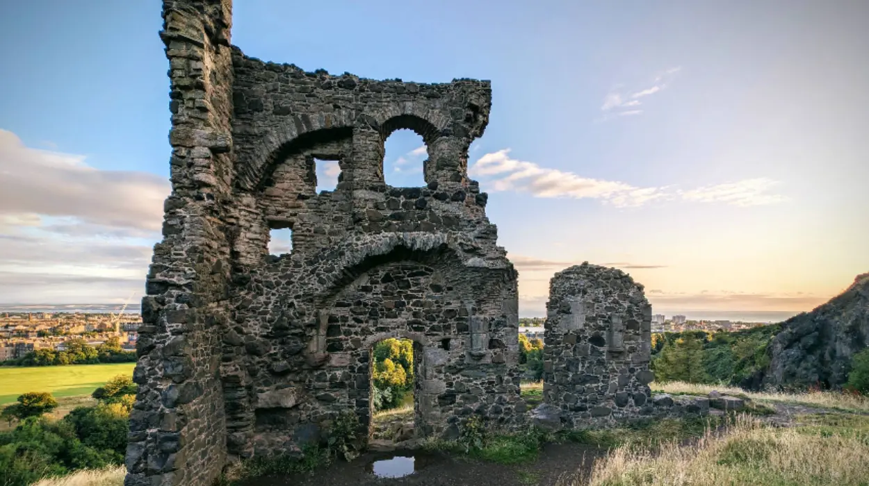
3 historic architectural structures remain standing, including St Anthony’s Chapel, Wells o’ Wearie, and the Salisbury Crags boundary wall. St Anthony’s Chapel stands as a ruined 15th-century stone structure perched on a rocky outcrop above St Margaret’s Loch. Historical documents link the chapel to Holyrood Abbey, serving as a beacon for pilgrims visiting the royal sanctuary.
How long does it take to walk up Arthur’s Seat?
The walk up Arthur’s Seat takes between 1.5 to 2.5 hours round trip, depending on your chosen starting point, fitness level, and route difficulty. Most visitors taking the direct northern route from Holyrood Palace reach the summit in 45 to 60 minutes and descend in 30 minutes.
Is climbing Arthur’s Seat suitable for beginners and children?
Climbing Arthur’s Seat is suitable for beginners, families, and older children with moderate mobility who wear sensible shoes with solid grip. While main grassy paths offer steady ascents, the final 50 metres involve uneven, steep rocky terrain requiring careful footing.
Can you drive up or park near Arthur’s Seat?
Vehicles cannot drive directly to the summit of Arthur’s Seat, as motorized access is strictly limited to perimeter park roads. Visitors can park at paid parking areas around Holyrood Park, including car parks near Dunsapie Loch along Queen’s Drive and near the Meadowbank entrance.
Is Arthur’s Seat an active volcano?
Arthur’s Seat is a completely extinct volcano that last erupted approximately 350 million years ago during the Carboniferous period. There is zero risk of volcanic activity, as the underlying magma chamber has been cold and solid for hundreds of millions of years.
Do you need tickets or entry fees to visit Arthur’s Seat?
No, visiting Arthur’s Seat and Holyrood Park is completely free of charge and open to the public 24 hours a day throughout the year. Access is managed by Historic Environment Scotland, allowing free walking along all designated public footpaths.